Earthquakes ranked by moment magnitude (Mw) from the USGS list of the world’s largest, as of October 13, 2026. The 1960 Valdivia earthquake in Chile, at Mw 9.5, is the largest ever measured, and all thirteen entries here are Mw 8.6 or greater.
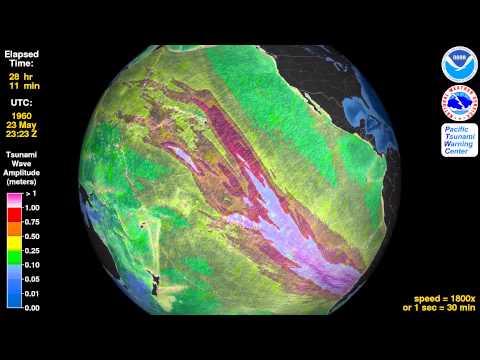
Pictured: the Pacific Tsunami Warning Center’s “Tsunami Animation: Valdivia, Chile, 1960” video, for the Valdivia earthquake, #1 with Mw 9.5.
Rank
Earthquake
Magnitude (Mw)
Date (UTC)
Location
Deaths (est.)
Tsunami
Region
Country
Era
1
Valdivia (Great Chilean) earthquake
9.5
1960-05-22
Bío-Bío / Valdivia region, Chile
~1,655 (estimates up to ~6,000)
Yes
Pacific Ring of Fire
Chile
1960–1999
2
Good Friday (Great Alaska) earthquake
9.2
1964-03-28
Prince William Sound, Alaska, USA
~131
Yes
Pacific Ring of Fire
United States
1960–1999
3
Sumatra–Andaman (Indian Ocean) earthquake
9.1
2004-12-26
Off northern Sumatra, Indonesia
~228,000 dead or missing (up to ~283,000)
Yes
Indian Ocean & Himalaya
Indonesia
2000+
3
Tōhoku (Great East Japan) earthquake
9.1
2011-03-11
Off Tōhoku coast, Japan
~15,900 dead, ~2,500 missing
Yes
Pacific Ring of Fire
Japan
2000+
5
Kamchatka (Severo-Kurilsk) earthquake
9.0
1952-11-04
Off Kamchatka, Russia
2,336 (official; est.)
Yes
Pacific Ring of Fire
Russia
Pre-1960
6
Ecuador–Colombia earthquake
8.8
1906-01-31
Off the coast of Ecuador
~500–1,500 (est.)
Yes
Pacific Ring of Fire
Ecuador / Colombia
Pre-1960
6
Maule (Chile) earthquake
8.8
2010-02-27
Offshore Maule / Bío-Bío, Chile
~525
Yes
Pacific Ring of Fire
Chile
2000+
6
Kamchatka earthquake
8.8
2025-07-29
Off Kamchatka Peninsula, Russia
None direct; 1 indirect (Japan)
Yes
Pacific Ring of Fire
Russia
2000+
9
Rat Islands earthquake
8.7
1965-02-04
Rat Islands, Aleutians, Alaska, USA
None documented
Yes
Pacific Ring of Fire
United States
1960–1999
10
Assam–Tibet earthquake
8.6
1950-08-15
Eastern Tibet–India border region
~1,500–4,800 (est.)
No (flooding from landslide dams)
Indian Ocean & Himalaya
India / China (Tibet)
Pre-1960
10
Andreanof Islands earthquake
8.6
1957-03-09
Andreanof Islands, Aleutians, Alaska, USA
None to 2 reported
Yes
Pacific Ring of Fire
United States
Pre-1960
10
Nias (Sumatra) earthquake
8.6
2005-03-28
Northern Sumatra, Indonesia
~900–1,700 (est.)
Yes
Indian Ocean & Himalaya
Indonesia
2000+
10
Northern Sumatra (strike-slip) earthquake
8.6
2012-04-11
Off northern Sumatra, Indonesia
Few (early reports ~5, indirect)
Yes (minor)
Indian Ocean & Himalaya
Indonesia
2000+
No matching rows.
As of October 13, 2026. Earthquakes are ranked by moment magnitude (Mw) as listed by the USGS; events with the same magnitude share a rank, listed oldest first. The table covers every earthquake of Mw 8.6 or above on the USGS list, so it is trimmed to 13 rows rather than padded with weaker entries (the USGS lists several Mw 8.5 events just below). Magnitudes for early-20th-century events are estimates reconstructed from old seismograms and have been revised over time; the 1906, 1950, 1952 and 1960 values differ by source (for example 1952 is quoted at 8.8–9.0 and 1950 at 8.6–8.8). Dates follow the USGS list in UTC, so some fall a day before local time. Death tolls are estimates and often include deaths from the tsunami, landslides and floods that followed; where counts disagree, a rounded or ranged figure is shown, and the sort uses the value in the table. Depth is not shown because sources disagree on it for most events. The 2012 and 1957 death figures are the least certain. Region means the Pacific Ring of Fire versus the Indian Ocean and Himalayan belt. 2026: searches found no earthquake of Mw 8 or above so far in 2026. The strongest found was a Mw 7.7 in southern Panama on October 9, 2026 (reports at first gave 7.6 or 8.0, then 7.7), far below this list.[1]
The Top 10
#1
Valdivia, Chile, 1960 — Mw 9.5
The Valdivia earthquake of May 22, 1960 is the largest ever recorded, at Mw 9.5 on the USGS list; other studies put it between 9.4 and 9.6.[2] The USGS-cited toll is about 1,655 deaths and roughly 2 million people left homeless, though estimates range widely, from under 1,000 to about 6,000.[2] The tsunami then crossed the Pacific, killing 61 people in Hilo, Hawaii about 15 hours later and 138 in Japan about 22 hours later.[2]
#2
Good Friday, Alaska, 1964 — Mw 9.2
Struck at 5:36 pm local time on Good Friday, March 27, 1964 (March 28 in UTC, the date used in the table), it is the largest earthquake in U.S. history.[3] Roughly 130 people died, most of them in the tsunamis rather than the shaking: Wikipedia counts 139, with 15 killed by the earthquake and 124 by the waves.[3] A local landslide-driven wave reached a run-up of about 67 m (220 ft) in Shoup Bay near Valdez, and the village of Chenega lost 23 of its 68 residents.[3]
#3
Sumatra–Andaman, 2004 — Mw 9.1
On December 26, 2004 the India and Burma plates slipped along their boundary off northern Sumatra, producing what the USGS says was the deadliest tsunami in recorded history.[4] The count depends on who is counted: NOAA’s NCEI lists 227,898 people dead or missing, while a USGS poster gives more than 275,000 killed and a scientific review reports over 283,000.[4] The disaster led directly to new tsunami warning systems for the Indian Ocean.
#3 (tie)
Tōhoku, Japan, 2011 — Mw 9.1
The March 11, 2011 earthquake ruptured the plate boundary between the Pacific and North America plates off Japan’s northeast coast.[5] It was first reported at a lower magnitude and revised upward to 9.1, and later studies range from about 8.7 to 9.2.[5] The tsunami reached a run-up of up to 40.5 m at Miyako. Counts are about 15,900 confirmed deaths and about 2,500 missing in the Japanese police tallies, and as high as 19,759 deaths in broader counts that include disaster-related deaths.[5]
#5
Kamchatka, Russia, 1952 — Mw 9.0
The earthquake of November 4, 1952 (UTC; November 5 in local time) is listed by the USGS at Mw 9.0, though Wikipedia gives a range of 8.8 to 9.0.[6] Its tsunami, about 18 m high, destroyed the town of Severo-Kurilsk; the commonly cited toll is 2,336, from a town population of about 6,000, with some estimates far higher.[6] The disaster was kept secret in the Soviet Union for years.[6] No suitable official video was found, so this entry uses the illustration.
#6
Ecuador–Colombia, 1906 — Mw 8.8
The January 31, 1906 earthquake off Ecuador’s coast is listed at Mw 8.8 by the USGS (from Kanamori, 1977), although Colombian sources quote 8.4.[7] Its tsunami hit the Colombian coast around Tumaco with waves of up to about 5 m. Death-toll estimates run from about 500 to 1,500, a wide range that reflects the limited records of the time.[7]
#6 (tie)
Maule, Chile, 2010 — Mw 8.8
The February 27, 2010 earthquake was shallow thrust faulting where the Nazca plate dives beneath South America. The USGS says the rupture was nearly 500 km long and more than 100 km wide, with slip of up to 15 m.[8] Roughly 525 people died, with official counts between 486 and 525 depending on the date, and the earthquake and tsunami destroyed more than 370,000 homes.[8]
#6 (tie)
Kamchatka, Russia, 2025 — Mw 8.8
The newest entry struck about 119 km east-southeast of Petropavlovsk-Kamchatsky at 23:24 UTC on July 29, 2025 (July 30 local time), after a Mw 7.4 foreshock on July 20.[9] It is the largest earthquake since Tōhoku in 2011. The Pacific-wide tsunami was mostly around 1 m or less, though a local run-up of 33.1 m was measured in a narrow valley near Vestnik Bay. No direct deaths were reported; Japan attributed one indirect death and about 21 injuries to the evacuation of nearly 2 million people.[9]
#9
Rat Islands, Alaska, 1965 — Mw 8.7
The February 4, 1965 earthquake ruptured about 600 km of the western Aleutian arc and produced a tsunami of about 10 m on Shemya Island.[10] It is remembered as a very large earthquake that caused little damage, because the area is so sparsely populated, and no deaths are documented. No suitable official video was found, so this entry uses the illustration.
#10
Assam–Tibet, 1950 — Mw 8.6
The August 15, 1950 earthquake in the Mishmi Hills, near the India–Tibet border, is the largest recorded earthquake caused by continental collision rather than subduction; its magnitude is quoted from 8.6 to 8.8.[11] It triggered huge landslides that dammed rivers, and the dams later burst and flooded villages downstream. Death-toll estimates range from about 1,500 to 4,800.[11] No suitable official video was found, so this entry uses the illustration.
USGS, “20 Largest Earthquakes in the World” and “10 Largest Earthquakes Ever Recorded (Updated 2025)” (magnitudes, dates in UTC and ranking, including the three-way Mw 8.8 tie); USGS Simple Seismicity of the Earth 1900–2007 (SIM 3064). Rows 11–13 (not written up above): Wikipedia, “1957 Andreanof Islands earthquake” (Mw 8.6; tsunami about $5 million damage in Hawaii; 0–2 deaths depending on source), Wikipedia and USGS field survey “Field survey of the March 28, 2005 Nias-Simeulue earthquake and tsunami” (Mw 8.6; Wikipedia counts 1,638–1,738 deaths, earlier reports 915–1,300), and EMSC and Dublin Institute for Advanced Studies reports on the April 11, 2012 Sumatra strike-slip earthquake (Mw 8.6; tsunami under 1 m; Mw 8.2 aftershock; the death figure is an early press report and could not be confirmed). 2026 status from Bernama/Anadolu and Jamaica Gleaner coverage of the October 9, 2026 Panama earthquake and AOL/AccuWeather on the March 24, 2026 Tonga Mw 7.5; no Mw 8+ event was found, and no search result was checked against the USGS catalog itself.
USGS and Wikipedia, “1960 Valdivia earthquake” (magnitude 9.4–9.6; deaths 1,655 to about 6,000; tsunami deaths in Hawaii, Japan and the Philippines); geology.com and earthquaketracker.org history entries.
USGS, “Magnitude 9.2: The 1964 Great Alaska Earthquake”; Wikipedia, “1964 Alaska earthquake” (139 deaths, Shoup Bay run-up, Chenega); Alaska Division of Geological & Geophysical Surveys 1964 report (114 deaths).
USGS, “Indian Ocean Tsunami Remembered” and the USGS 2004 event poster (Mw 9.1, more than 275,000 killed); NOAA NCEI count of 227,898 dead or missing as quoted by CNN Fast Facts; Lay et al., “The Great Sumatra-Andaman Earthquake of 26 December 2004” (over 283,000).
USGS event page “M 9.1 – 2011 Great Tohoku Earthquake, Japan”; Wikipedia, “2011 Tōhoku earthquake and tsunami” (19,759 deaths, 2,553 missing, 40.5 m run-up, magnitude revisions and range); Japan National Police Agency counts as quoted by Simple Wikipedia (15,890) and IRIS (15,899).
Wikipedia, “1952 Severo-Kurilsk earthquake” and “List of earthquakes in 1952” (Mw 8.8–9.0, 18 m tsunami, 2,336–14,000 dead); PreventionWeb, “Soviet Union’s secret tsunami”; USGS 10-largest summary (Mw 9.0).
Wikipedia, “1906 Ecuador–Colombia earthquake”; The Weather Network, “This day in weather history: January 31, 1906”; Colombian press (Vanguardia, El País, Blu Radio) for the 8.4 figure and 600–1,500 deaths; USGS table (Kanamori, 1977). Death toll is a rough historical estimate.
USGS event page “M 8.8 – 36 km WNW of Quirihue, Chile” (rupture dimensions, slip); IRIS and Strong Motion Center summaries; Simple Wikipedia and OCHA ReliefWeb for the death toll (486–525), USGS 10-largest summary for the homes figure.
USGS event page “M 8.8 – 2025 Kamchatka Peninsula, Russia Earthquake” and USGS aftershock forecast; Wikipedia, “2025 Kamchatka earthquake” (magnitude 8.7–8.8, run-up, one indirect death in Japan); CTIF and press reports for the roughly 2 million evacuation advisories in Japan.
Wikipedia, “1965 Rat Islands earthquake”; Alaska Earthquake Center, “1965 M8.7 Rat Islands Earthquake” (600 km rupture). No death toll was found in an authoritative source; “none documented” reflects Wikipedia’s description of very little damage.
Wikipedia, “1950 Assam–Tibet earthquake” and “List of earthquakes in 1950” (Mw 8.6–8.8; 4,800 versus 1,530 dead); SoundSeismic summary for the landslide-dam flood; Indian press summaries for the 1,500 figure.
Video embeds were found by youtube.com-restricted searches and each video’s uploader and title were confirmed through YouTube’s oEmbed lookup: the Valdivia 1960, Tōhoku 2011, Maule 2010 and Kamchatka 2025 videos are from the Pacific Tsunami Warning Center (PacificTWC) channel; the 1964 video is from the USGS channel; the 2004 video is from the NOAA channel; the 1906 video is from The Weather Network. The Kamchatka 2025 video is a forecast-model animation, not footage. Entries with the illustration (1952, 1965, 1950) had no suitable official video. Public availability was inferred from the oEmbed lookup and not tested by playing each video.